|
Bangladesh
|
|
Capital: Dhaka
Population: 163,046,161
Brief History of Bangladesh:
The area that is now Bangladesh has been settled for many thousands of years. There have been a series of ruling dynasties including the Buddhist Pala dynasty and the Hindu Sena dynasty. By the 12th century, Arab merchants had come to Bengal and the religion of Islam had begun to spread. In the 16th century, The Mughal Empire took control of Bengal and the city of Dhaka became an important center of the Mughal administration.
The first Europeans to visit Bangladesh were Portuguese traders. Soon the French, British, and Dutch followed. The British became the dominant presence primarily through the East India Company. In 1859, Britain took over and Bengal became part of the British Empire as a region of India.
In 1947, the region of Bengal was divided along religious lines. The mostly Muslim eastern half was called East Pakistan and became part of Pakistan. The mostly Hindu western part was part of the country of India and was the state West Bengal.
There were many arguments and wars between Pakistan and India. As a result the new country of Bangladesh was created in 1972. It was a parliamentary democracy with a constitution. The capital was in Dhaka. Justice Abu Sayeed Choudhury was the first President and Sheikh Mujibur Rahman (Mujib) the first Prime Minister.
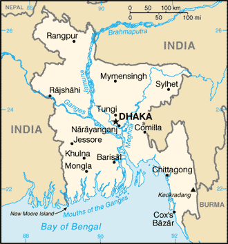
The Geography of Bangladesh
Total Size: 144,000 square km
Size Comparison: slightly smaller than Iowa
Geographical Coordinates: 24 00 N, 90 00 E
World Region or Continent: Asia
General Terrain: mostly flat alluvial plain; hilly in southeast
Geographical Low Point: Indian Ocean 0 m
Geographical High Point: Keokradong 1,230 m
Climate: tropical; mild winter (October to March); hot, humid summer (March to June); humid, warm rainy monsoon (June to October)
Major cities: DHAKA (capital) 14.251 million; Chittagong 4.816 million; Khulna 1.636 million; Rajshahi 853,000 (2009)
The People of Bangladesh
Type of Government: parliamentary democracy
Languages Spoken: Bangla (official, also known as Bengali), English
Independence: 16 December 1971 (from West Pakistan); note - 26 March 1971 is the date of independence from West Pakistan, 16 December 1971 is known as Victory Day and commemorates the official creation of the state of Bangladesh
National Holiday: Independence Day, 26 March (1971); note - 26 March 1971 is the date of independence from West Pakistan, 16 December 1971 is Victory Day and commemorates the official creation of the state of Bangladesh
Nationality: Bangladeshi(s)
Religions: Muslim 83%, Hindu 16%, other 1% (1998)
National Symbol: Bengal tiger
National Anthem or Song: Amar Shonar Bangla (My Golden Bengal)
Economy of Bangladesh
Major Industries: cotton textiles, jute, garments, tea processing, paper newsprint, cement, chemical fertilizer, light engineering, sugar
Agricultural Products: rice, jute, tea, wheat, sugarcane, potatoes, tobacco, pulses, oilseeds, spices, fruit; beef, milk, poultry
Natural Resources: natural gas, arable land, timber, coal
Major Exports: garments, jute and jute goods, leather, frozen fish and seafood (2001)
Major Imports: machinery and equipment, chemicals, iron and steel, textiles, foodstuffs, petroleum products, cement (2000)
Currency: taka (BDT)
National GDP: $283,500,000,000
** Source for population (2012 est.) and GDP (2011 est.) is CIA World Factbook.
Back to Geography Home Page