|
Paraguay
|
|
Capital: Asuncion
Population: 7,044,636
Brief History of Paraguay:
The original inhabitants of Paraguay were fierce warrior tribal peoples. The first European explorers arrived in Paraguay in the 16th century. Juan de Salazar, a Spanish explorer, established the city of Asuncion in 1537. Asuncion would become the center of the Spanish colony.
In 1811 Paraguay declared independence and expelled the local Spanish government. Three powerful men ruled the land over the next 80 years: the first was Jose de Francia, next was Carlos Lopez, and finally Carlos' son Francisco Lopez. In 1864, during the rule of Francisco Lopez, Paraguay fought the War of the Triple Alliance against Argentina, Uruguay, and Brazil. Paraguay lost the war and lost two thirds of its adult male population as well as much of its land.
The mid-1900s were a period of unrest and civil war. Alfredo Stroessner became dictator in 1954 and ruled for 35 years. During this time, freedoms were severely limited in Paraguay. Since his death elections have been relatively free.
The Geography of Paraguay
Total Size: 406,750 square km
Size Comparison: slightly smaller than California
Geographical Coordinates: 23 00 S, 58 00 W
World Region or Continent: South America
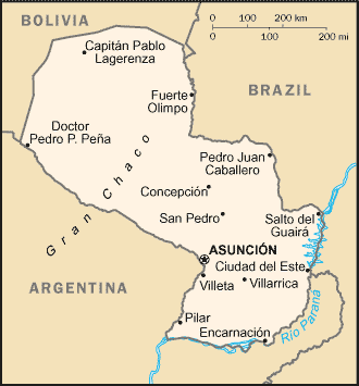
General Terrain: grassy plains and wooded hills east of Rio Paraguay; Gran Chaco region west of Rio Paraguay mostly low, marshy plain near the river, and dry forest and thorny scrub elsewhere
Geographical Low Point: junction of Rio Paraguay and Rio Parana 46 m
Geographical High Point: Cerro Pero (Cerro Tres Kandu) 842 m
Climate: subtropical to temperate; substantial rainfall in the eastern portions, becoming semiarid in the far west
Major cities: ASUNCION (capital) 1.977 million (2009), Ciudad del Este, San Lorenzo
The People of Paraguay
Type of Government: constitutional republic
Languages Spoken: Spanish (official), Guarani (official)
Independence: 14 May 1811 (from Spain)
National Holiday: Independence Day, 14 May 1811 (observed 15 May annually)
Nationality: Paraguayan(s)
Religions: Roman Catholic 90%, Mennonite and other Protestant 10%
National Symbol: lion
National Anthem or Song: Paraguayos, Republica o muerte! (Paraguayans, The Republic or Death!)
Economy of Paraguay
Major Industries: sugar, cement, textiles, beverages, wood products, steel, metallurgic, electric power
Agricultural Products: cotton, sugarcane, soybeans, corn, wheat, tobacco, cassava (tapioca), fruits, vegetables; beef, pork, eggs, milk; timber
Natural Resources: hydropower, timber, iron ore, manganese, limestone
Major Exports: soybeans, feed, cotton, meat, edible oils, electricity, wood, leather
Major Imports: road vehicles, consumer goods, tobacco, petroleum products, electrical machinery
Currency: guarani (PYG)
National GDP: $40,640,000,000
** Source for population (2012 est.) and GDP (2011 est.) is CIA World Factbook.
Back to Geography Home Page