|
Tuvalu
|

|
Capital: Funafuti
Population: 11,646
Brief History of Tuvalu:
Tuvalu is an island nation in the South Pacific. The islands were settled by Polynesians many thousands of years ago. There was very little contact with Europeans until the 19th century. In the 20th century the area became part of a British colony.
During World War II, troops from the United States were located on the islands. The US built several airbases on different islands. Tuvalu became an independent nation in 1978 and still has good relations with the USA.
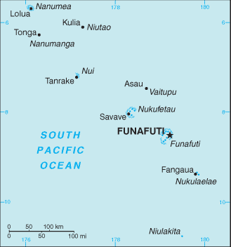
The Geography of Tuvalu
Total Size: 26 square km
Size Comparison: 0.1 times the size of Washington, DC
Geographical Coordinates: 8 00 S, 178 00 E
World Region or Continent: Oceania
General Terrain: very low-lying and narrow coral atolls
Geographical Low Point: Pacific Ocean 0 m
Geographical High Point: unnamed location 5 m
Climate: tropical; moderated by easterly trade winds (March to November); westerly gales and heavy rain (November to March)
Major cities:
The People of Tuvalu
Type of Government: constitutional monarchy with a parliamentary democracy
Languages Spoken: Tuvaluan, English, Samoan, Kiribati (on the island of Nui)
Independence: 1 October 1978 (from UK)
National Holiday: Independence Day, 1 October (1978)
Nationality: Tuvaluan(s)
Religions: Church of Tuvalu (Congregationalist) 97%, Seventh-Day Adventist 1.4%, Baha'i 1%, other 0.6%
National Symbol:
National Anthem or Song: Tuvalu mo te Atua (Tuvalu for the Almighty)
Economy of Tuvalu
Major Industries: fishing, tourism, copra
Agricultural Products: coconuts; fish
Natural Resources: fish
Major Exports: copra, fish
Major Imports: food, animals, mineral fuels, machinery, manufactured goods
Currency: Australian dollar (AUD); note - there is also a Tuvaluan dollar
National GDP: $36,000,000
** Source for population (2012 est.) and GDP (2011 est.) is CIA World Factbook.
Back to Geography Home Page
