|
Haiti
|
|
Capital: Port-au-Prince
Population: 11,263,770
Brief History of Haiti:
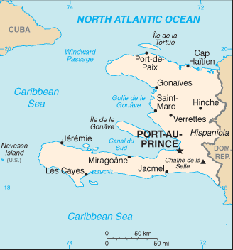
Haiti is located on the western third of the island of Hispaniola. The island of Hispaniola was first inhabited by local peoples, the Tainos. They are also sometimes called the Arawaks. Christopher Columbus landed on the island in 1492 during his first voyage to the Americas. He claimed the island for the Spanish and it soon became the main base for future Spanish explorations and conquests into the rest of the Caribbean and the Americas. In 1496, Santo Domingo was established. It was the first permanent settlement in the New World.
When Columbus and the Europeans arrived in Hispaniola, the area was inhabited by hundreds of thousands of the native Taino peoples. However, the number of natives declined rapidly as diseases brought by the Europeans, such as smallpox, spread and quickly killed them. In 1697 the French gained control of the western third of the island from Spain. This area later became Haiti.
The French imported slaves from Africa to help farm crops on Haiti, especially sugarcane. The colony became wealthy during this time. However, in the late 1700s the slaves revolted under the leadership of Toussaint L'Ouverture. They declared their independence from France in 1804. Unfortunately, since then things have not gone well for Haiti. It is the poorest country in the Western Hemisphere and its government has been plagued with political violence. To make things worse, Haiti was hit by a massive earthquake in January 2010. Much of the country was destroyed and it will be years until it can recover.
The Geography of Haiti
Total Size: 27,750 square km
Size Comparison: slightly smaller than Maryland
Geographical Coordinates: 19 00 N, 72 25 W
World Region or Continent: Central America
General Terrain: mostly rough and mountainous
Geographical Low Point: Caribbean Sea 0 m
Geographical High Point: Chaine de la Selle 2,680 m
Climate: tropical; semiarid where mountains in east cut off trade winds
Major cities: PORT-AU-PRINCE (capital) 2.143 million (2010), Carrefour, Delmas
The People of Haiti
Type of Government: elected government
Languages Spoken: French (official), Creole (official)
Independence: 1 January 1804 (from France)
National Holiday: Independence Day, 1 January (1804)
Nationality: Haitian(s)
Religions: Roman Catholic 80%, Protestant 16% (Baptist 10%, Pentecostal 4%, Adventist 1%, other 1%), none 1%, other 3%
National Symbol: Hispaniolan trogon (bird)
National Anthem or Song: La Dessalinienne (The Dessalines Song)
Economy of Haiti
Major Industries: sugar refining, flour milling, textiles, cement, light assembly industries based on imported parts
Agricultural Products: coffee, mangoes, sugarcane, rice, corn, sorghum; wood
Natural Resources: bauxite, copper, calcium carbonate, gold, marble, hydropower
Major Exports: manufactures, coffee, oils, cocoa, mangoes
Major Imports: food, manufactured goods, machinery and transport equipment, fuels, raw materials
Currency: gourde (HTG)
National GDP: $12,370,000,000
** Source for population (2012 est.) and GDP (2011 est.) is CIA World Factbook.
Back to Geography Home Page