|
Burma
|

|
Capital: Rangoon (Yangon)
Population: 54,045,420
Brief History of Burma:
The area that is today the country of Burma has been ruled by major dynasties in the past. In 1044AD the Bagan Dynasty came into power. This time is often called the Golden Age of Burma. It was during this time at Buddhism became a major religion in Burma. The kings of the Bagan Dynasty built many Buddhist shrines and pagodas. This time lasted for around 150 years until the Mongol invaders arrived.
The next major dynasty formed in region was the Taungoo Dynasty in 1486. This dynasty expanded the empire and ruled for over 250 years. It was followed by the Konbaung Dynasty. The first king of the Konbaung was King Alaungpaya. This was a warring dynasty which fought the Chinese, the Siamese, and later the British. They fell to the British Empire in 1885. At this time Burma became a part of British India.
After WWII the Burmese wanted their independence from Britain. Their leader was General Aung San. Burma gained independence in January of 1948. Burma initially had a constitutional government, but there was much fighting for power within the country. Military leaders took over. In 1990, when the military group lost the elections, they refused to accept the results and imprisoned many political figures who opposed them. Even today political leaders such as Augn San Suu Kyi are held in prison because they do not agree with the military government.
Today Burma is country with much unrest and few political freedoms.
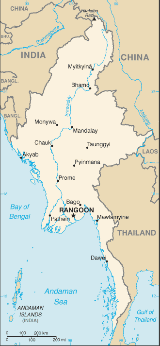
The Geography of Burma
Total Size: 678,500 square km
Size Comparison: slightly smaller than Texas
Geographical Coordinates: 22 00 N, 98 00 E
World Region or Continent: Southeast Asia
General Terrain: central lowlands ringed by steep, rugged highlands
Geographical Low Point: Andaman Sea 0 m
Geographical High Point: Hkakabo Razi 5,881 m
Climate: tropical monsoon; cloudy, rainy, hot, humid summers (southwest monsoon, June to September); less cloudy, scant rainfall, mild temperatures, lower humidity during winter (northeast monsoon, December to April)
Major cities: RANGOON (capital) 4.259 million; Mandalay 1.009 million; Nay Pyi Taw 992,000 (2009)
The People of Burma
Type of Government: military junta
Languages Spoken: Burmese, minority ethnic groups have their own languages
Independence: 4 January 1948 (from UK)
National Holiday: Independence Day, 4 January (1948); Union Day, 12 February (1947)
Nationality: Burmese (singular and plural)
Religions: Buddhist 89%, Christian 4% (Baptist 3%, Roman Catholic 1%), Muslim 4%, animist 1%, other 2%
National Symbol: chinthe (mythical lion)
National Anthem or Song: Kaba Ma Kyei (Till the End of the World, Myanmar)
Economy of Burma
Major Industries: agricultural processing; knit and woven apparel; wood and wood products; copper, tin, tungsten, iron; construction materials; pharmaceuticals; fertilizer; cement; natural gas
Agricultural Products: rice, pulses, beans, sesame, groundnuts, sugarcane; hardwood; fish and fish products
Natural Resources: petroleum, timber, tin, antimony, zinc, copper, tungsten, lead, coal, some marble, limestone, precious stones, natural gas, hydropower
Major Exports: clothing, gas, wood products, pulses, beans, fish, rice
Major Imports: fabric, petroleum products, plastics, machinery, transport equipment, construction materials, crude oil; food products
Currency: kyat (MMK)
National GDP: $82,680,000,000
** Source for population (2012 est.) and GDP (2011 est.) is CIA World Factbook.
Back to Geography Home Page