|
Belgium
|
|
Capital: Brussels
Population: 11,539,328
Brief History of Belgium:
The country of Belgium gets its name from the original settlers of the area. They were a Celtic tribe called the Belgae. The Belgae lived in the area of Belgium until they were conquered by the Roman Empire in 100 BC. The area became a productive province of the Roman Empire for the next 300 years.
When the Roman Empire began to fade, Germanic tribes invaded Belgium and took over. Northern Belgium became very German during this time, learning the language and culture. The southern part of Belgium continued to act more Roman and spoke Latin. Over the next several hundred years Belgium came under the rule of many different dynasties and empires. For a while they were under the rule of the Spanish and then later the Habsburg Empire of Austria. Belgium's location made it the center of many European industries including textiles, commerce, and art. Great cities such as Brussels, Antwerp, and Ghent rose up to be leaders in the world. Belgium's central European location also made it the site of many wars, including being invaded by Germany in WWI and WWII.
In 1795 Belgium became part of France after being captured during the Napoleonic wars. After the war it became part of the Netherlands. This didn't last for too long, however, as the Belgian people rose up and rebelled against the Dutch. In 1830, they gained their independence.
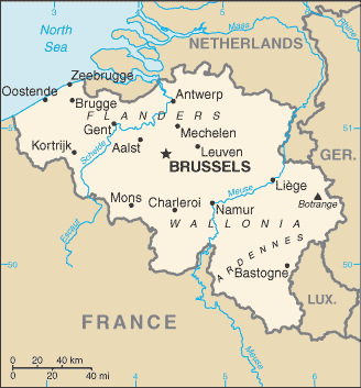
Because of the differences in cultures in Belgium, there is a formal border within the country that divides the country into different languages. They even have fairly different governments. In the north is the Dutch speaking area and in the South is French speaking. There is also a smaller area in the east that speaks German.
The Geography of Belgium
Total Size: 30,528 square km
Size Comparison: about the size of Maryland
Geographical Coordinates: 50 50 N, 4 00 E
World Region or Continent: Europe
General Terrain: flat coastal plains in northwest, central rolling hills, rugged mountains of Ardennes Forest in southeast
Geographical Low Point: North Sea 0 m
Geographical High Point: Signal de Botrange 694 m
Climate: temperate; mild winters, cool summers; rainy, humid, cloudy
Major cities: BRUSSELS (capital) 1.892 million; Antwerp 961,000 (2009), Ghent, Charleroi
The People of Belgium
Type of Government: federal parliamentary democracy under a constitutional monarchy
Languages Spoken: Dutch (official) 60%, French (official) 40%, German (official) less than 1%, legally bilingual (Dutch and French)
Independence: 4 October 1830 (a provisional government declares independence from the Netherlands); 21 July 1831 (King Leopold I ascends to the throne)
National Holiday: 21 July (1831) ascension to the Throne of King Leopold I
Nationality: Belgian(s)
Religions: Roman Catholic 75%, Protestant or other 25%
National Symbol: lion
National Anthem or Song: La Brabanconne (The Song of Brabant)
Economy of Belgium
Major Industries: engineering and metal products, motor vehicle assembly, transportation equipment, scientific instruments, processed food and beverages, chemicals, basic metals, textiles, glass, petroleum
Agricultural Products: sugar beets, fresh vegetables, fruits, grain, tobacco; beef, veal, pork, milk
Natural Resources: construction materials, silica sand, carbonates
Major Exports: machinery and equipment, chemicals, diamonds, metals and metal products, foodstuffs
Major Imports: machinery and equipment, chemicals, diamonds, pharmaceuticals, foodstuffs, transportation equipment, oil products
Currency: euro (EUR)
National GDP: $413,700,000,000
** Source for population (2012 est.) and GDP (2011 est.) is CIA World Factbook.
Back to Geography Home Page