|
Northern Mariana Islands
|
|
Capital: Saipan
Population: 56,188
Brief History of Northern Mariana Islands:
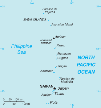
The Northern Mariana Islands is an island country located in the Pacific Ocean between Hawaii and the Philippines. There are 15 islands in that make up the territory. Most of the population lives on the island of Saipan.
The first European to arrive on the islands was Ferdinand Magellan in 1521. Later the Spanish would lay claim to the islands. Today the island nation is under United States administration as part of the United Nations Trust Territory of the Pacific.
The Geography of Northern Mariana Islands
Total Size: 477 square km
Size Comparison: 2.5 times the size of Washington, DC
Geographical Coordinates: 15 12 N, 145 45 E
World Region or Continent: Oceania
General Terrain: southern islands are limestone with level terraces and fringing coral reefs; northern islands are volcanic
Geographical Low Point: Pacific Ocean 0 m
Geographical High Point: unnamed location on Agrihan 965 m
Climate: tropical marine; moderated by northeast trade winds, little seasonal temperature variation; dry season December to June, rainy season July to October
Major cities: SAIPAN (capital) NA (2009)
The People of Northern Mariana Islands
Type of Government: commonwealth; self-governing with locally elected governor, lieutenant governor, and legislature
Languages Spoken: Philippine languages 24.4%, Chinese 23.4%, Chamorro 22.4%, English 10.8%, other Pacific island languages 9.5%, other 9.6% (2000 census)
Independence: none (commonwealth in political union with the US)
National Holiday: Commonwealth Day, 8 January (1978)
Nationality: NA (US citizens)
Religions: Christian (Roman Catholic majority, although traditional beliefs and taboos may still be found)
National Symbol: latte stone
National Anthem or Song: Gi Talo Gi Halom Tasi (In the Middle of the Sea)
Economy of Northern Mariana Islands
Major Industries: tourism, construction, garments, handicrafts
Agricultural Products: coconuts, fruits, vegetables; cattle
Natural Resources: arable land, fish
Major Exports: garments
Major Imports: food, construction equipment and materials, petroleum products
Currency: US dollar (USD)
National GDP: $900,000,000
** Source for population (2012 est.) and GDP (2011 est.) is CIA World Factbook.
Back to Geography Home Page