|
Lesotho
|
|
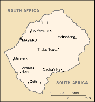
Capital: Maseru
Population: 2,125,268
Brief History of Lesotho:
Lesotho was originally inhabited by local tribes of hunter-gatherers called the Khoisan. Later came the Bantu tribes and eventually the Sotho-Tswana peoples. In 1822 Kin Moshoeshoe I united the land under one rule for the first time. The land was called Basutoland at the time. When Europeans arrived first he French had control, but the British took over in 1795. It was renamed Lesotho when it gained independence in 1966. For the first 20 years the Basuto National Party remained in power. The country has since had changes in power and leaders with many protests and some unrest.
The Geography of Lesotho
Total Size: 30,355 square km
Size Comparison: slightly smaller than Maryland
Geographical Coordinates: 29 30 S, 28 30 E
World Region or Continent: Africa
General Terrain: mostly highland with plateaus, hills, and mountains
Geographical Low Point: junction of the Orange and Makhaleng Rivers 1,400 m
Geographical High Point: Thabana Ntlenyana 3,482 m
Climate: temperate; cool to cold, dry winters; hot, wet summers
Major cities: MASERU (capital) 220,000 (2009)
The People of Lesotho
Type of Government: parliamentary constitutional monarchy
Languages Spoken: Sesotho (southern Sotho), English (official), Zulu, Xhosa
Independence: 4 October 1966 (from UK)
National Holiday: Independence Day, 4 October (1966)
Nationality: Mosotho (singular), Basotho (plural)
Religions: Christian 80%, indigenous beliefs 20%
National Symbol: Basotho hat
National Anthem or Song: Lesotho fatse la bo ntat'a rona (Lesotho, Land of Our Fathers)
Economy of Lesotho
Major Industries: food, beverages, textiles, apparel assembly, handicrafts, construction, tourism
Agricultural Products: corn, wheat, pulses, sorghum, barley; livestock
Natural Resources: water, agricultural and grazing land, diamonds, sand, clay, building stone
Major Exports: manufactures 75% (clothing, footwear, road vehicles), wool and mohair, food and live animals (2000)
Major Imports: food; building materials, vehicles, machinery, medicines, petroleum products (2000)
Currency: loti (LSL); South African rand (ZAR)
National GDP: $3,723,000,000
** Source for population (2012 est.) and GDP (2011 est.) is CIA World Factbook.
Back to Geography Home Page