|
Eritrea
|
|
Capital: Asmara (Asmera)
Population: 3,497,117
Brief History of Eritrea:
The land that is now Eritrea was ruled by various powers around the Red Sea area for most of history. In 1885, the Italians took control and made Eritrea a colony. They tried to use the land as a base to take over Ethiopia. They failed. After World War II, Italy lost the land to Great Britain and in 1952 the land was combined with Ethiopia into a single country. The Eritreans wanted their own country as they felt they would not be treated fairly by the Ethiopians. They were denied, however.
The Eritreans rebelled and struggled for their freedom for thirty years. They finally achieved their independence in 1993. They still have hostilities with Ethiopia and a dispute over the border between the two countries.
The Geography of Eritrea
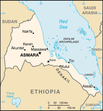
Total Size: 121,320 square km
Size Comparison: slightly larger than Pennsylvania
Geographical Coordinates: 15 00 N, 39 00 E
World Region or Continent: Africa
General Terrain: dominated by extension of Ethiopian north-south trending highlands, descending on the east to a coastal desert plain, on the northwest to hilly terrain and on the southwest to flat-to-rolling plains
Geographical Low Point: near Kulul within the Denakil depression -75 m
Geographical High Point: Soira 3,018 m
Climate: hot, dry desert strip along Red Sea coast; cooler and wetter in the central highlands (up to 61 cm of rainfall annually, heaviest June to September); semiarid in western hills and lowlands
Major cities: ASMARA (capital) 649,000 (2009), Keren
The People of Eritrea
Type of Government: transitional government
Languages Spoken: Afar, Arabic, Tigre and Kunama, Tigrinya, other Cushitic languages
Independence: 24 May 1993 (from Ethiopia)
National Holiday: Independence Day, 24 May (1993)
Nationality: Eritrean(s)
Religions: Muslim, Coptic Christian, Roman Catholic, Protestant
National Symbol: camel
National Anthem or Song: Ertra, Ertra, Ertra (Eritrea, Eritrea, Eritrea)
Economy of Eritrea
Major Industries: food processing, beverages, clothing and textiles, salt, cement, commercial ship repair
Agricultural Products: sorghum, lentils, vegetables, corn, cotton, tobacco, coffee, sisal; livestock, goats; fish
Natural Resources: gold, potash, zinc, copper, salt, possibly oil and natural gas, fish
Major Exports: livestock, sorghum, textiles, food, small manufactures (2000)
Major Imports: machinery, petroleum products, food, manufactured goods (2000)
Currency: nakfa (ERN)
National GDP: $4,037,000,000
** Source for population (2012 est.) and GDP (2011 est.) is CIA World Factbook.
Back to Geography Home Page