|
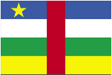
Central African Republic
|
|
Capital: Bangui
Population: 4,745,185
Brief History of Central African Republic:
The Central African Republic is also sometimes referred to as C.A.R. It was first settled in the 7th century by a number of empires. They included the Ouaddai, the Baguirmi, the Danem-Bornou, and the Dafour. The Arabs came later and the land was claimed by Sultans. The Sultans used the land to capture slaves to sell to European traders.
Europeans arrived in the Central African Republic (CAR) in 1885. The French laid claim to the land took full control of the area in 1903. The area became a territory of the Federation of French Equatorial Africa, also called the AEF.
After WWII the French started to work towards an independent country. On December 1, 1958 the Central African Republic was born. The first leader of the government was a Catholic priest named Barthelemy Boganda. Unfortunately, the free Central African Republic has since been marred by a series of military coups and a lack of credible elections or democracy.
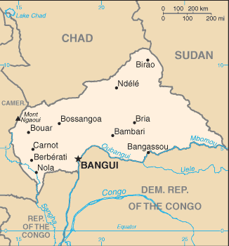
The Geography of Central African Republic
Total Size: 622,984 square km
Size Comparison: slightly smaller than Texas
Geographical Coordinates: 7 00 N, 21 00 E
World Region or Continent: Africa
General Terrain: vast, flat to rolling, monotonous plateau; scattered hills in northeast and southwest
Geographical Low Point: Oubangui River 335 m
Geographical High Point: Mont Ngaoui 1,420 m
Climate: tropical; hot, dry winters; mild to hot, wet summers
Major cities: BANGUI (capital) 702,000 (2009), Bimbo
The People of Central African Republic
Type of Government: republic
Languages Spoken: French (official), Sangho (lingua franca and national language), tribal languages
Independence: 13 August 1960 (from France)
National Holiday: Republic Day, 1 December (1958)
Nationality: Central African(s)
Religions: indigenous beliefs 35%, Protestant 25%, Roman Catholic 25%, Muslim 15%
National Symbol: elephant
National Anthem or Song: Le Renaissance (The Renaissance)
Economy of Central African Republic
Major Industries: gold and diamond mining, logging, brewing, textiles, footwear, assembly of bicycles and motorcycles
Agricultural Products: cotton, coffee, tobacco, manioc (tapioca), yams, millet, corn, bananas; timber
Natural Resources: diamonds, uranium, timber, gold, oil, hydropower
Major Exports: diamonds, timber, cotton, coffee, tobacco
Major Imports: food, textiles, petroleum products, machinery, electrical equipment, motor vehicles, chemicals, pharmaceuticals
Currency: Communaute Financiere Africaine franc (XAF); note - responsible authority is the Bank of the Central
National GDP: $3,636,000,000
** Source for population (2012 est.) and GDP (2011 est.) is CIA World Factbook.
Back to Geography Home Page